 |
National Hurricane Center upgrades Isaac to hurricane
Source:
wafb.com
- Aug 28, 2012
BATON ROUGE, LA (WAFB) -
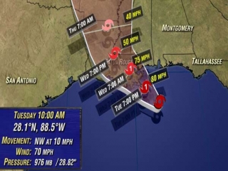
The National Hurricane Center has announced Isaac is officially classified as a hurricane with maximum sustained winds at 75 mph.
Isaac's track has shifted to the west, putting Baton Rouge on the east side of the storm, meaning the city will now experience stronger winds and heavier rains.
Tropical storm force winds (greater than 39 mph) will be possible for a prolonged period on Wednesday.
The storm remains on its path in the Gulf of Mexico as it slowly makes its way to the southeast coast of Louisiana.
The storm's forward speed was at 10 mph. Its general northwest motion is expected to continue.
On its current track, Isaac will likely make landfall in southeast Louisiana by early afternoon on Tuesday. It is expected to be a category 1 storm with maximum sustained winds around 85 mph. The slow-moving storm is predicted to be over or near Baton Rouge Wednesday afternoon. The Capital area is forecast to feel wind gusts of 30 mph-plus Tuesday afternoon.
A Tornado Watch has been issued for Lafourche, St. John the Baptist, Tangipahoa and Terrebonne parishes. It remains in effect until 7 p.m.
Hurricane Warnings remain in effect from Morgan City eastward to the Alabama/Florida border. The warning includes metro New Orleans and parishes surrounding Lake Pontchartrain and Lake Maurepas. A Tropical Storm Warning is in effect for the remainder of southeast Louisiana, including metro Baton Rouge.
Specific impacts in a given neighborhood will be highly dependent on the exact track. While the latest official forecast track keeps Isaac to the east of Baton Rouge, there is still reliable guidance that brings the storm near or west of the Capital City. The Storm Team emphasizes that considerable uncertainty remains and all residents of south Louisiana should prepare for potential hurricane conditions. Latest National Hurricane Center Advisories
A Flash Flood Watch is in effect for most of the WAFB viewing area.
The following Louisiana parishes are affected:
Ascension
Assumption
East Baton Rouge
East Feliciana
Iberville
Jefferson
Lafourche
Livingston
Orleans
Plaquemines
Pointe Coupee
St. Bernard
St. Charles
St. Helena
St. James
St. John the Baptist
St. Tammany
Tangipahoa
Terrebonne
Washington
West Baton Rouge
West Feliciana
The following Mississippi counties are included:
Amite
Hancock
Harrison
Jackson
Pearl River
Pike
Walthall
Forecasters said heavy rainfall is a big concern due to Isaac's anticipated slow movement. Widespread rainfall totals of 6 to 12 inches can be expected near and east of the track, with isolated amounts of 15 to 20 inches possible.
A hurricane warning remains in effect for the following Louisiana parishes:
Ascension
Assumption
Jefferson
Lafourche
Livingston
Orleans
Plaquemines
St. Bernard
St. Charles
St. James
St. John the Baptist
St. Tammany
Tangipahoa
Terrebonne
The following Mississippi counties are in the warning area:
Hancock
Harrison
Jackson
Pearl River
A tropical storm warning continues for the following Louisiana parishes:
East Baton Rouge
East Feliciana
Iberville
Pointe Coupee
St. Helena
St. Mary
West Baton Rouge
West Feliciana
The following Mississippi counties are also under the tropical storm warning:
Amite
Pike
Walthall
Wilkinson
Copyright 2012 WAFB. All rights reserved
Category: Louisiana
|

